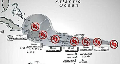
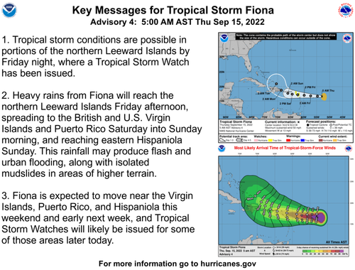
After a relatively quiet hurricane season, with no named storms in August, a new tropical system has formed in the Atlantic Basin that should be monitored into the weekend.
Tropical Storm Fiona, the sixth named storm of the 2022 Atlantic hurricane season, is moving westward with sustained winds above 50 mph. It's about 625 miles east of the Leeward Islands and strengthened from a tropical depression Wednesday.
The islands of Saba, St. Eustatius, St. Maarten, Montserrat, Antigua, Barbuda, St. Kitts, Nevis, and Anguilla have all issued tropical storm watches. Additional watches and warnings could be issued today.
"On the forecast track, the center of the storm is forecast to move through the Leeward Islands late Friday and Friday night, and be near the Virgin Islands and Puerto Rico this weekend," the hurricane center said.
Meteorologist
Zach Covey pointed out that most models show Fiona could hook right
into the Atlantic on Monday. At least one model shows the storm could
traverse into the Northern Gulf of Mexico, while another shows it riding
up the US East Coast.
Tropical Storm #Fiona will be tracking through Hebert Box 1 - something most Florida meteorologists know well. The boxes, named after former NHC forecaster Paul Hebert, are two regions used as predictors for hurricanes that can strike South Florida. pic.twitter.com/758NaXGuXJ
— Zach Covey (@ZachCoveyTV) September 15, 2022
It's still too early to determine what path Fiona takes next week, but it's a storm to watch.
World Weather TV:

